Control Vision's AnywhereWX software:
I purchased the AWX software and GPS to go with an HP 5455 iPaq in May 2003. A couple times a year I find myself wishing (and willing to pay almost any price) for Nexrad capability in night IFR. I am using this in our 1979 Bellanca Viking. I don't think this will increase the utility of our airplane, but it sure will increase my comfort level in terms of knowing what's out there. I still have some learning to go in terms of how to best use the software and how the displayed weather compares to actual weather, but am impressed so far with the ability to get weather at a reasonable price. I have looked at on-board Nexrad (including all the other products) for several years and finally bought AWX...one distinct advantage of AWX - it's not vaporware like most of the rest of the products being advertised.
Some pictures of actual weather enroute are below:
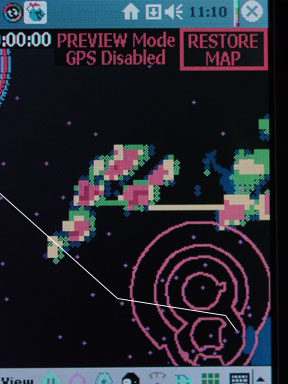
The picture below is a screen shot returning from Colorado to Houston on 5/26/03 about 4:00pm local time. For a sense of zoom scale, the circle at the bottom is the Houston Class B which is 60 nm diameter. The circle at top is the Dallas Class B. As you can see there is a big area of light-moderate weather South of Dallas and a larger area Northeast of Houston. Both were moving South. Forecast was for scattered TS along the entire route, with TAF's showing TS arrival a few hours after our ETA. When we departed Pueblo the WSI Nexrad showed a pretty wide gap between the major weather areas leaving our planned route of flight pretty clear. Nearing Houston a little line built right in our path, oddly enough moving North. This weather download was done about 2 minutes before we got to that little line (so it was about 7 minutes old or so).
fyi, the little blue dots all over are airports...there is no way to turn them off at any clutter level...the Garmin 295 kills them with one touch at any zoom level and automatically kills them when zoomed out...I hope CV will add the ability to turn off all but flight-planned airports just like you can turn off almost everything else.
Next is the same picture, zoomed much closer. This shows the pixel size of the weather display (the iPaq pixel size is much smaller of course). I found the resolution plenty adequate - you absolutely would not have wanted to be in the pink or red near our course line in a little airplane. Where we went through showed yellow on the iPaq (the tint is off in my digital pic of the iPaq screen)...we were actually in VMC the whole time (on an IFR flight plan), wiggling our way through, mostly to learn what the actual conditions were compared to the AWX. At night (my primary reason for buying this tool), I would have absolutely wanted to have avoided the whole little area with a slight deviation to the South (even VMC, we hit CAT hard enough to bump our heads - in those clouds would have been much worse). btw, there was no apparent lightning in this line, so it wouldn't have shown up at night visually.
Again, the airport identifiers really clutter up the screen and there is no way to turn them off.
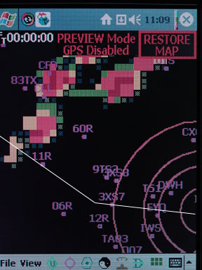
Next is the resolution I ran during most of the trip. I find both the iPaq and the Garmin 295 have interesting and helpful unique features, but so far still prefer my 295 for pure navigation - mostly screen redraw speed and visibility-wise (although the iPaq is much more readable in bright sunlight than I thought, the Garmin is way better, particularly with polarizing sunglasses on) but also because the iPaq would not fit well on my yoke with the bottom plug. As a result I have it mounted on a suction cup mounted gooseneck on the co-pilots side and have a hot-key set to download weather with one touch - for the most part that is all I did with it the whole trip after inputting the flight plan...one touch every hour.